Case Study – IRLAB
The following case study is presented by IRLAB (Institute for Research and Learning in Archaeology and Bioarcheology), a 501 (c)(3) organization conducting research projects on funerary and archaeological contexts both in Italy and in the United States. The skeleton (identified by the code USk2110) shown here belong to an adult individual (about 25 y.o.) uncovered in a 19* century rural cemetery in central Ohio (Harrison Township Cholera Cemetery) where a cholera epidemic took place in 1832 and 1849.
All the burials uncovered, in addition to being the object of anthropological, taphonomic and funerary analysis, are entered into a Geographic Information System that preserved their original topographic orientation.
Subsequently, Total Station and single photogrammetric models are joined, allowing for all single burials to be studied even once they are removed from their original location.
In order to make the excavation results more accessible to the public, every single individual’s 3D model has been uploaded to a ‘virtual cemetery’. Since all the information about the burials obtained in the field and the lab represents a sort of renewed identity, the project has been called “The Closest Thing To a Name”.
The survey
Since the archaeological site is uploaded on a GIS, every single find (tombstones, stratifications, artefacts, burials) is georeferred, by using markers and Total Station, in a WGS84 coordinate system in a UTM 17N projection. The survey is completed with pictures, in this specific case taken with a Nikon D3000 Reflex camera and 52 pictures. The 3D model and registration realized in 3D Zephyr Aerial.
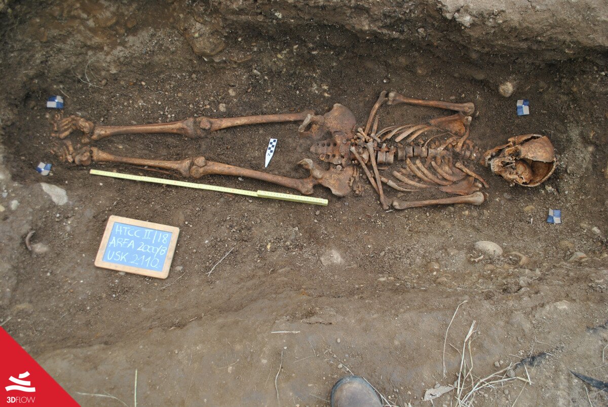
Individual USk2110 at the time of recovery
The Point Cloud
Many finds are often hard to interpret either because of soil disruption or by their own nature (for instance hand bones, once soft tissues are decomposed the single elements lose their anatomical position spreading around or concentrating in specific areas). For this reason, more photographs were taken on specifical anatomical districts (cranium, thorax, pelvis) while basic photosets were considered sufficient for areas that are easier to read (e.g., lower limb).
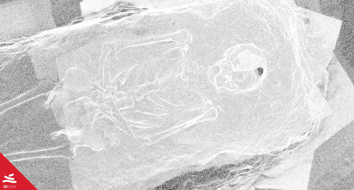
The point cloud and mesh shows, thanks to points density, which areas have been photographed more
Interpretability
Analogic sketches and draws have always been susceptible to errors and oversights due to human factors. Photogrammetry is founded on real images and this allows to approach the model as an actual replica of the find in situ, avoiding other people’s interpretation. No element is lost, and depths are more eloquent than one offered by a restricted number of sections and many unreachable spots now can be navigated on the 3D model.
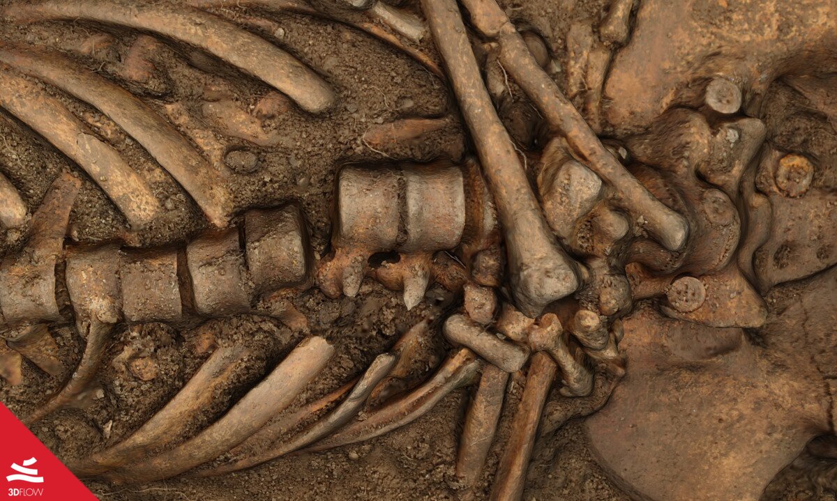
The two pictures above are close ups on hard-to-read areas, liable to be subjected to graphic errors in the case of analog survey. Depths and heights, reachable on every single point of the cloud allow the model “speak” even to people who physically cannot interact with it on site.
Control Points
Markers inside the burial cut have been geolocated by Total Station and exported in .ply format. By using the ‘registration’ tool the model has been scaled and aligned to the field-checked point cloud after assigning the control points on the model itself.
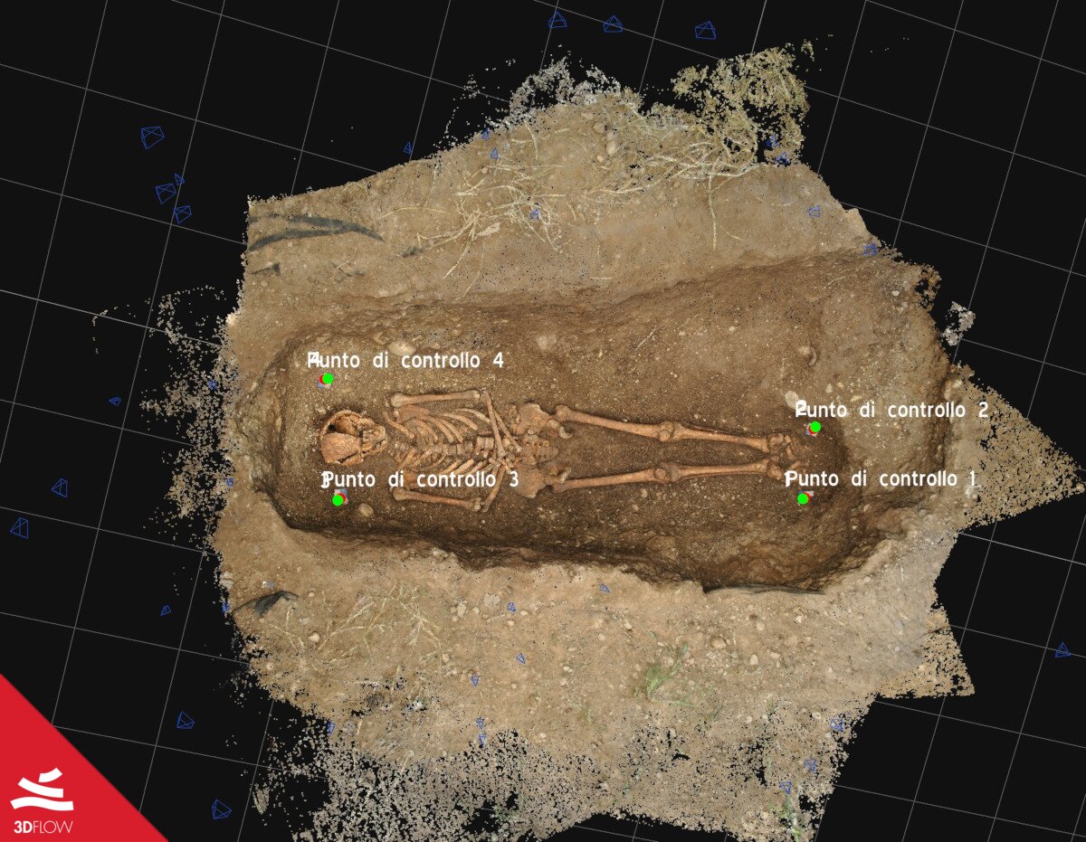
The rescaled and geolocated model. From this moment onward, every single element within the cloud is measurable in all its dimensions
Not only large scales
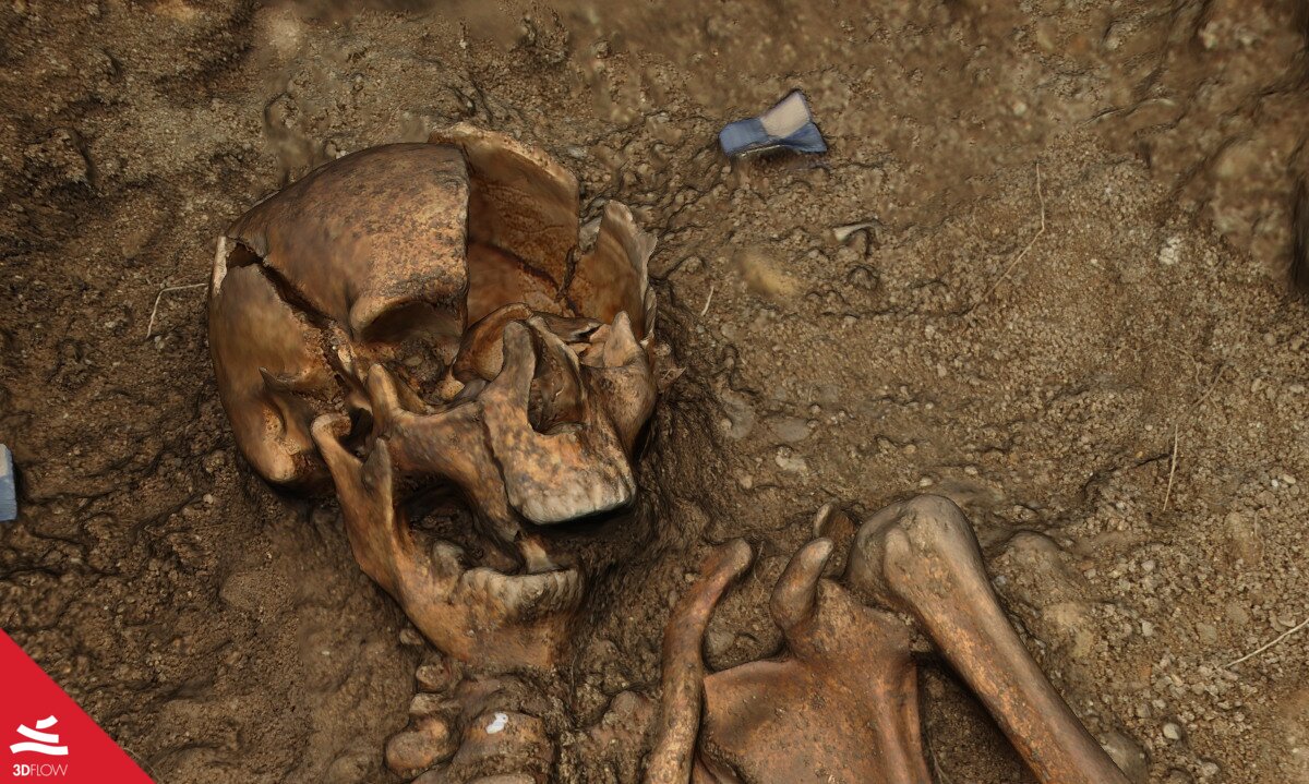
In the specific case of human burials, many measures taken in situ are extremely important because they cannot be replicated in the lab. That is because perishable elements, such as soft tissues and clothes, and the position of the body represents an original volume, of which is the skeleton is its last surviving element, that is lost at the moment of the discovery. Furthermore, detection of bone dislocation (such as pelvis flattening) allows determining if the decomposition took place inside a coffin or whether the soil penetrated through the wood, thus preserving articulations in place by keeping the bones connected (empty\filled space decomposition). Studying these dislocations provides information about events occurred after the burial, such as animals leading to the movement of some bones, soil collapse, or voluntary anthropic manipulation.
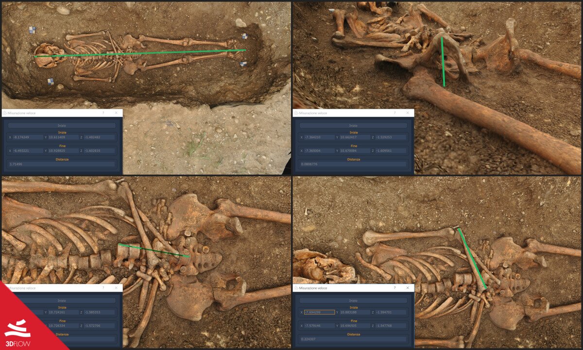
The 1:1 scaled model is now entirely measurable in its every single part, even in spots that are extremely fragile after hundreds of years of interment. In contrast with direct measuring of a find, which could endanger its integrity, virtual measurements are entirely safe.